The technique of moving by terrain association is more forgiving of mistakes and far less time-consuming than dead reckoning. It best suits those situations that call for movement from one area to another. Errors made using terrain association are easily corrected because you are comparing what you expected to see from the map to what you do see on the ground. Errors are anticipated and will not go unchecked. You can easily make adjustments based upon what you encounter. Periodic position-fixing through either plotted or estimated resection will also make it possible to correct your movements, call for fire, or call in the locations of enemy targets or any other information of tactical or logistical importance.
a. Matching the Terrain to the Map by Examining Terrain Features. By observing the contour lines in detail, the five major terrain features (hilltop, valley, ridge, depression, and saddle) should be determined. This is a simple task in an area where the observer has ample view of the terrain in all directions. One-by-one, match the terrain features depicted on the map with the same features on the ground. In restricted terrain, this procedure becomes harder; however, constantly check the map as you move since it is the determining factor (Figure 11-5).
b. Comparing the Vegetation Depicted on the Map. When comparing the vegetation, a topographic map should be used to make a comparison of the clearings that appear on the map with the ones on the ground. The user must be familiar with the different symbols, such as vineyards, plantations, and orchards that appear on the legend. The age of the map is an important factor when comparing vegetation. Some important vegetation features were likely to be different when the map was made. Another important factor about vegetation is that it can change overnight by natural accidents or by man (forest fires, clearing of land for new developments, farming, and so forth).
c. Masking by the Vegetation. Camouflage the important landforms using vegetation. Use of camouflage makes it harder for the navigator to use terrain association.
d. Using the Hydrography. Inland bodies of water can help during terrain association. The shape and size of lakes in conjunction with the size and direction of flow of the rivers and streams are valuable help.
e. Using Man-made Features. Man-made features are an important factor during terrain association. The user must be familiar with the symbols shown in the legend representing those features. The direction of buildings, roads, bridges, high-tension lines, and so forth make the terrain inspection a lot easier; however, the age of the map must be considered because man-made features appear and disappear constantly.
f. Examining the Same Piece of Terrain During the Different Seasons of the Year. In those areas of the world where the seasons are distinctive, a detailed examination of the terrain should be made during each of the seasons. The same piece of land does not present the same characteristics during both spring and winter.
(1) During winter, the snow packs the vegetation, delineating the land, making the terrain features appear as clear as they are shown by the contour lines on the map. Ridges, valleys, and saddles are very distinctive.
(2) During spring, the vegetation begins to reappear and grow. New vegetation causes a gradual change of the land to the point that the foliage conceals the terrain features and makes the terrain hard to recognize.
(3) During summer months, the effects are similar to those in the spring.
(4) Fall makes the land appear different with its change of color and gradual loss of vegetation.
(5) During the rainy season, the vegetation is green and thick, and the streams and ponds look like small rivers and lakes. In scarcely vegetated areas, the erosion changes the shape of the land.
(6) During a period of drought, the vegetation dries out and becomes vulnerable to forest fires that change the terrain whenever they occur. Also during this season, the water levels of streams and lakes drop, adding new dimensions and shape to the existing mapped areas.
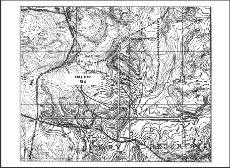
g. Following an Example of Terrain Association. Your location is hilltop 514 in the lower center of the map in Figure 11-7.
(1) To The North. The contour lines indicate that the hill slopes down for about 190 meters, and that it leads into a small valley containing an intermittent stream. On the other side of the stream as you continue with your northerly inspection, the terrain starts a gradual ascent, indicating a hilltop partially covered with vegetation, until an unimproved road is reached. This road runs along a gradual ridgeline with north-west direction. Then the contour line spacings become narrow, indicating a steeper grade that leads to a narrow valley containing a small intermittent stream. As you continue up, you find a small but prominent ridge with a clearing. The contour lines once again show a steeper grade leading to a moderate valley containing an intermittent stream running in a south-east direction.
(2) To The East. There is a clearing of the terrain as it slopes down to Schley Pond. An ample valley is clearly seen on the right side of the pond, as indicated by the "U" and "V" shape of the contour lines. This valley contains some swamp areas and there is a long ridgeline on the north portion of the valley.
(3) To The South. The terrain gently slopes downward until a clear area is reached. It continues in a downward direction to an intermittent stream running south-east in a small valley. There is also an improved road running in the same direction as the valley. At the intersection of the roads as you face south, there is a clearing of about 120 meters on the ridge. At the bottom of it, a stream runs from Schley Pond in a south-west direction through an ample valley fed by two intermittent streams. As you continue, a steep, vegetated hill is found with a clearing on its top, followed by a small saddle and another hilltop.
(4) To The West. First, you see a small, clear valley. It is followed by a general ridgeline running north-west in which an unimproved road is located just before a hilltop. Continuing on a westerly direction, you will find a series of alternate valleys and ridges.