Orienting the Map
The first step for a navigator in the field is orienting the map. A map is oriented when it is in a horizontal position with its north and south corresponding to the north and south on the ground. Some orienting techniques follow:
a. Using a Compass. When orienting a map with a compass, remember that the compass measures magnetic azimuths. Since the magnetic arrow points to magnetic north, pay special attention to the declination diagram. There are two techniques used.
(1) First Technique. Determine the direction of the declination and its value from the declination diagram.
(a) With the map in a horizontal position, take the straightedge on the left side of the compass and place it alongside the north-south grid line with the cover of the compass pointing toward the top of the map. This procedure places the fixed black index line of the compass parallel to north-south grid lines of the map.
(b) Keeping the compass aligned as directed above, rotate the map and compass together until the magnetic arrow is below the fixed black index line on the compass. At this time, the map is close to being oriented.
(c) Rotate the map and compass in the direction of the declination diagram.
(d) If the magnetic north arrow on the map is to the left of the grid north, check the compass reading to see if it equals the G-M angle given in the declination diagram. The map is then oriented (Figure 11-1).
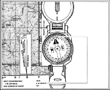
Figure 11-1. Map oriented with 11 degrees west declination.
(e) If the magnetic north is to the right of grid north, check the compass reading to see if it equals 360 degrees minus the G-M angle (Figure 11-2).
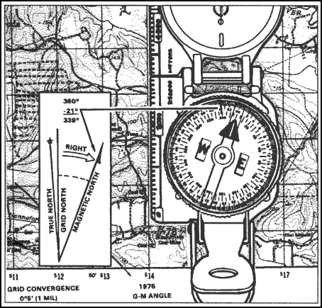
Figure 11-2. Map oriented with 21 degrees east declination.
(2) Second Technique. Determine the direction of the declination and its value from the declination diagram.
(a) Using any north-south grid line on the map as a base, draw a magnetic azimuth equal to the G-M angle given in the declination diagram with the protractor.
(b) If the declination is easterly (right), the drawn line is equal to the value of the G-M angle. Then align the straightedge, which is on the left side of the compass, alongside the drawn line on the map. Rotate the map and compass until the magnetic arrow of the compass is below the fixed black index line. The map is now oriented (Figure 11-3).
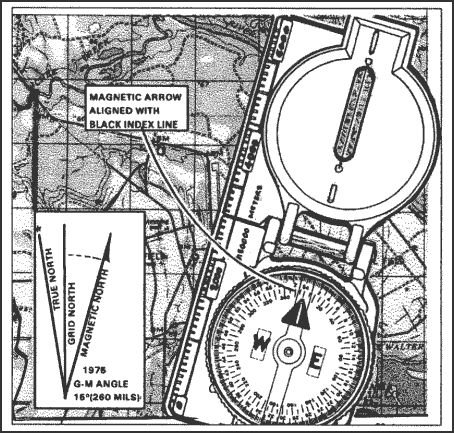
Figure 11-3. Map oriented with 15 degrees east declination.
(c) If the declination is westerly (left), the drawn line will equal 360 degrees minus the value of the G-M angle. Then align the straightedge, which is on the left side of the compass, alongside the drawn line on the map. Rotate the map and compass until the magnetic arrow of the compass is below the fixed black index line. The map is now oriented (Figure 11-4).
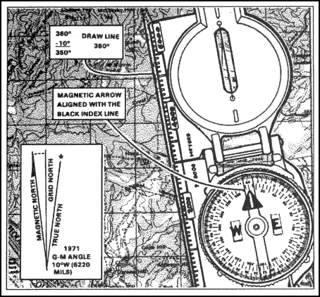
Figure 11-4. Map oriented with 10 degrees west declination.
| NOTE: |
1. Once the map is oriented, magnetic azimuths are determined using the compass. Do not move the map from its oriented position since any change in its position moves it out of line with the magnetic north.
2. Special care should be taken whenever orienting your map with a compass. A small mistake can cause you to navigate in the wrong direction. |
b. Using Terrain Association. A map can be oriented by terrain association when a compass is not available or when the user has to make many quick references as he moves across country. Using this method requires careful examination of the map and the ground, and the user must know his approximate location (Figure 11-5). Orienting by this method is discussed in detail in latter parts of this section.
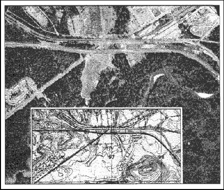
Figure 11-5. Terrain association.
c. Using Field-Expedient Methods. When a compass is not available and there are no recognizable terrain features, a map may be oriented by any of the field-expedient methods described here. Also see Figure 11-6.
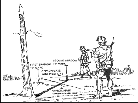
Figure 11-6. Field-expedient method.
Back to Terrain Association
|


