Locate a Point Using Grid CoordinatesBased on the military principle for reading maps (RIGHT and UP), locations on the map can be determined by grid coordinates. The number of digits represents the degree of precision to which a point has been located and measured on a map— the more digits the more precise the measurement.
a. Without a Coordinate Scale. Determine grids without a coordinate scale by referring to the north-south grid lines numbered at the bottom margin of any map. Then read RIGHT to the north-south grid line that precedes the desired point (this first set of two digits is the RIGHT reading). Then by referring to the east-west grid lines numbered at either side of the map, move UP to the east-west grid line that precedes the desired point (these two digits are the UP reading). Coordinate 1484 locate the 1,000-meter grid square in which point X is located; the next square to the right would be 1584; the next square up would be 1485, and so forth (Figure 4-15). Locate the point to the nearest 100 meters using estimation. Mentally divide the grid square in tenths, estimate the distance from the grid line to the point in the same order (RIGHT and UP). Give complete coordinate RIGHT, then complete coordinate UP. Point X is about two-tenths or 200 meters to the RIGHT into the grid square and about seven-tenths or 700 meters UP.
RESULTS: The coordinates to the nearest 100 meters are 142847.
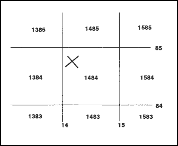
Figure 4-15. Determining grids without coordinate point.
b. With a Coordinate Scale (1:25,000). In order to use the coordinate scale for determining grid coordinates, ensure that the appropriate scale is being used on the corresponding map, and that the scale is right side up. To ensure the scale is correctly aligned, place it with the zero-zero point at the lower left corner of the grid square. Keeping the horizontal line of the scale directly on top of the east-west grid line, slide it to the right until the vertical line of the scale touches the point for which the coordinates are desired (Figure 4-16). When reading coordinates, examine the two sides of the coordinate scale to ensure that the horizontal line of the scale is aligned with the east-west grid line, and the vertical line of the scale is parallel with the north-south grid line. Use the scale when precision of more than 100 meters is required. To locate the point to the nearest 10 meters, measure the hundredths of a grid square RIGHT and UP from the grid lines to the point. Point X is about 17 hundredths or 170 meters RIGHT and 84 hundredths or 840 meters UP. The coordinates to the nearest 10 meters are 14178484.
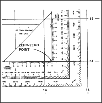
Figure 4-16. Placing a coordinate scale on a grid.
| NOTE: |
Care should be exercised by the map reader using the coordinate scale when the desired point is located within the zero-zero point and the number 1 on the scale. Always prefix a zero if the hundredths reading is less than 10. In Figure 4-17, the desired point is reported as 14818407. |
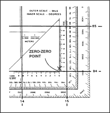
Figure 4-17. Zero-zero point.
c. 1:50,000 Coordinating Scale. On the 1:50,000 coordinate scale, there are two sides: vertical and horizontal. These sides are 1,000 meters in length. The point at which the sides meet is the zero-zero point. Each side is divided into 10 equal 100-meter segments by a long tick mark and number. Each 100-meter segment is subdivided into 50-meter segments by a short tick mark (Figure 4-18). By using interpolation, mentally divide each 50-meter segment into tenths. For example, a point that lies after a whole number but before a short tick mark is identified as 10, 20, 30, or 40 meters and any point that lies after the short tick mark but before the whole number is identified as 60, 70, 80, or 90 meters.

Figure 4-18. 1:50,000 coordinating scale.
d. Example of Obtaining an Eight-Digit Coordinate Using 1:50,000 Scale. To ensure the scale is correctly aligned, place it with the zero-zero point at the lower left corner of the grid square. Keeping the horizontal line of the scale directly on top of the east-west grid line, slide the scale to the right until the vertical line of the scale touches the point for which the coordinates are desired (Figure 4-19). Reading right, you can see that the point lies 530 meters to the right into the grid square, which gives a right reading of 7853. Reading up, you can see that the point lies 320 meters up into the grid square, giving an up reading of 0032.
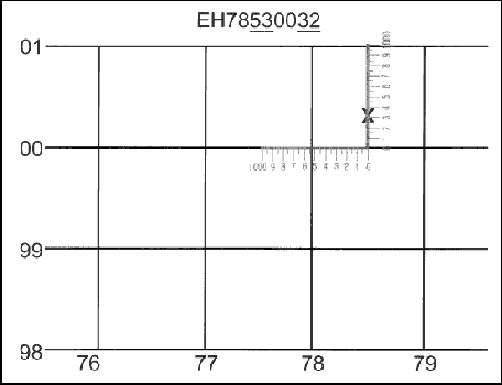
Figure 4-19. Example of obtaining an eight-digit coordinate using 1:50,000 scale.
e. Recording and Reporting Grid Coordinates. Coordinates are written as one continuous number without spaces, parentheses, dashes, or decimal points; they must always contain an even number of digits. Therefore, whoever is to use the written coordinates must know where to make the split between the RIGHT and UP readings. It is a military requirement that the 100,000-meter square identification letters be included in any point designation. Normally, grid coordinates are determined to the nearest 100 meters (six digits) for reporting locations. With practice, this can be done without using plotting scales. The location of targets and other point locations for fire support are determined to the nearest 10 meters (eight digits).
| NOTE: |
Special care should be exercised when recording and reporting coordinates. Transposing numbers or making errors could be detrimental to military operations. |
Back to Grids
|


