Types of Slopes
Depending on the military mission, soldiers may need to determine not only the height of a hill, but the degree of the hill's slope as well. The rate of rise or fall of a terrain feature is known as its slope. The speed at which equipment or personnel can move is affected by the slope of the ground or terrain feature. This slope can be determined from the map by studying the contour lines—the closer the contour lines, the steeper the slope; the farther apart the contour lines, the gentler the slope. Four types of slopes that concern the military are as follows:
a. Gentle. Contour lines showing a uniform, gentle slope will be evenly spaced and wide apart (Figure 10-6). Considering relief only, a uniform, gentle slope allows the defender to use grazing fire. The attacking force has to climb a slight incline.

Figure 10-6. Uniform, gentle slope.
b. Steep. Contour lines showing a uniform, steep slope on a map will be evenly spaced, but close together. Remember, the closer the contour lines, the steeper the slope (Figure 10-7). Considering relief only, a uniform, steep slope allows the defender to use grazing fire, and the attacking force has to negotiate a steep incline.
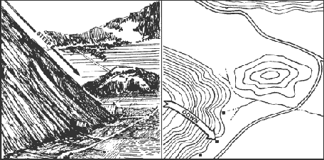
Figure 10-7. Uniform, steep slope.
c. Concave. Contour lines showing a concave slope on a map will be closely spaced at the top of the terrain feature and widely spaced at the bottom (Figure 10-8). Considering relief only, the defender at the top of the slope can observe the entire slope and the terrain at the bottom, but he cannot use grazing fire. The attacker would have no cover from the defender's observation of fire, and his climb would become more difficult as he got farther up the slope.
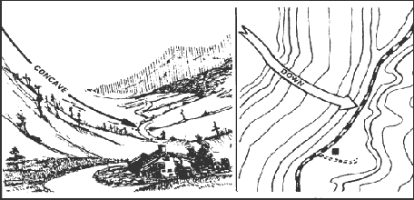
Figure 10-8. Concave slope.
d. Convex. Contour lines showing a convex slope on a map will be widely spaced at the top and closely spaced at the bottom (Figure 10-9). Considering relief only, the defender at the top of the convex slope can obtain a small distance of grazing fire, but he cannot observe most of the slope or the terrain at the bottom. The attacker will have concealment on most of the slope and an easier climb as he nears the top.
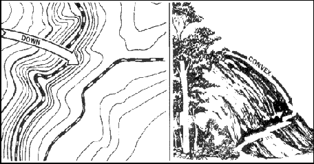
Figure 10-9. Convex slope.
Back to Elevation and Relief
|


