Representative Fraction
The numerical scale of a map indicates the relationship of distance measured on a map and the corresponding distance on the ground. This scale is usually written as a fraction and is called the representative fraction. The RF is always written with the map distance as 1 and is independent of any unit of measure. (It could be yards, meters, inches, and so forth. ) An RF of 1/50,000 or 1:50,000 means that one unit of measure on the map is equal to 50,000 units of the same measure on the ground.
a. The ground distance between two points is determined by measuring between the same two points on the map and then multiplying the map measurement by the denominator of the RF or scale (Figure 5-1).
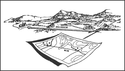
Figure 5-1. Converting map distance to ground distance.
EXAMPLE:
The map scale is 1:50,000
RF = 1/50,000
The map distance from point A to point B is 5 units
5 x 50,000 = 250,000 units of ground distance
b. Since the distance on most maps is marked in meters and the RF is expressed in this unit of measurement in most cases, a brief description of the metric system is needed. In the metric system, the standard unit of measurement is the meter.
1 meter contains 100 centimeters (cm).
100 meters is a regular football field plus 10 meters.
1,000 meters is 1 kilometer (km).
10 kilometers is 10,000 meters.
Appendix C contains the conversion tables.
c. The situation may arise when a map or sketch has no RF or scale. To be able to determine ground distance on such a map, the RF must be determined. There are two ways to do this:
(1) Comparison with Ground Distance.
(a) Measure the distance between two points on the map—map distance (MD).
(b) Determine the horizontal distance between these same two points on the ground—ground distance (GD).
(c) Use the RF formula and remember that RF must be in the general form:
(d) Both the MD and the GD must be in the same unit of measure and the MD must be reduced to 1.
EXAMPLE:
MD = 4. 32 centimeters
GD = 2. 16 kilometers
(216,000 centimeters)
| RF |
= |
1 |
= |
4. 32 |
| —— |
—— |
| X |
216,000 |
or
| 216,000 |
= |
50,000 |
| —— |
| 4. 32 |
therefore
| RF |
= |
1 |
or |
1:50,000 |
| —— |
| 50,000 |
(2) Comparison With Another Map of the Same Area that Has an RF.
(a) Select two points on the map with the unknown RF. Measure the distance (MD) between them.
(b) Locate those same two points on the map that have the known RF. Measure the distance (MD) between them. Using the RF for this map, determine GD, which is the same for both maps.
(c) Using the GD and the MD from the first map, determine the RF using the formula:
d. Occasionally it may be necessary to determine map distance from a known ground distance and the RF:
| MD |
= |
GD |
| ———————— |
| Denominator or RF |
Ground Distance = 2,200 meters
RF = 1:50,000
| MD |
= |
2,200 meters |
| ———————— |
| 50,000 |
MD = 0. 044 meters x 100 (centimeters per meter)
MD = 4. 4 centimeters
e. When determining ground distance from a map, the scale of the map affects the accuracy. As the scale becomes smaller, the accuracy of measurement decreases because some of the features on the map must be exaggerated so that they may be readily identified.
Back to Scale and Distance
|


