Training Network: Wilderness Survival | Fitness Training  
Fitness Training
 

The Sport:

  • Orienteering History
  • Orienteering Overview
  • Course Setup
  • Officials
  • Start/Finish Areas
  • Course Safety
  • Control Point Guidelines
  • Map Symbols
  • Orienteering Techniques
  • Civilian Orienteering

    The Skills:

  • Maps
  • Marginal Information and Symbols
  • Grids
  • Scale and Distance
  • Direction
  • Overlays
  • Aerial Photographs
  • Navigation Equipment and Methods
  • Elevation and Relief
  • Terrain Association
  • Navigation in Different Types of Terrain

  • Field Sketching
  • Map Folding Techniques
  • Units of Measure and Conversion Factors

  • Grid Reference Box

    A grid reference box (Figure 4-23) appears in the marginal information of each map sheet. It contains step-by-step instructions for using the grid and the US Army military grid reference system. The grid reference box is divided into two parts.

    Figure 4-23.  Grid reference box

    Figure 4-23. Grid reference box

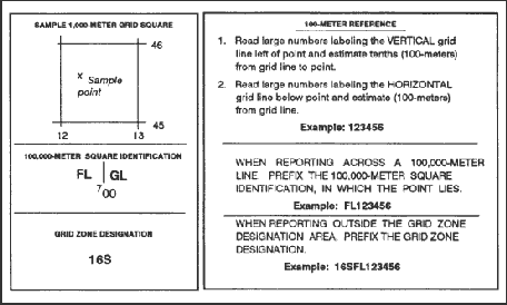
    a.   The left portion identifies the grid zone designation and the 100,000-meter square. If the sheet falls in more than one 100,000-meter square, the grid lines that separate the squares are shown in the diagram and the letters identifying the 100,000-meter squares are given.

    EXAMPLE:   On the Columbus map sheet, the vertical line labeled 00 is the grid line that separates the two 100,000-meter squares, FL and GL. The left portion also shows a sample for the 1,000-meter square with its respective labeled grid coordinate numbers and a sample point within the 1,000-meter square.

    b.   The right portion of the grid reference box explains how to use the grid and is keyed on the sample 1,000-meter square of the left side. The following is an example of the military grid reference:

    EXAMPLE:   16S locates the 6° by 8° area (grid zone designation).

    Back to Grids

    Copyright © 2001-2005 Jalic LLC. All Rights Reserved.
    Disclaimer | Privacy Policy | Contact Us